The Public Security Police (PSP) launched yesterday a trilingual – Chinese, English and Portuguese – traffic accident blackspot online map.
According to a PSP statement on Wednesday, in order to further enhance public awareness of travel safety, the Public Security Police and the Macau Public Security Forces Affairs Bureau (DSFSM) jointly developed the map, adding that the map’s data has been provided by the Mapping and Land Registry Bureau (DSCC).
The Public Security Police Force includes the traffic police.
The map integrates traffic accident data and locations with particularly high frequencies of accidents, aiming to easily enable the public to access traffic accident information, thereby raising awareness of travel safety, the statement said.
The statement said that clicking on the corresponding circles on the map reveals locations within a 50-metre radius where more than 10 traffic accidents have occurred, differentiated by colour.
For instance, a black circle indicates that fatal accidents were involved within the respective area, while the orange circle indicate the most frequent occurrence of accidents within the respective area.
Details include the causes of accidents, the number of incidents, the quantity of vehicles involved and casualty figures, among other information, the statement said, added that the data is updated quarterly.
The map released yesterday shows that Avenida Dr. Rodrigo Rodrigues was Macau’s most accident-prone road, totalling 258 accidents between January and September. Friendship Bridge (Ponte da Amizade) came in second, with 258 accidents, while the so-called Cotai Strip came in third, with 191 accidents.
In the first 10 months of this year, the traffic police recorded 12,363 traffic accidents, four of them fatal, compared to 12,976 traffic accidents with two fatalities in the same period of last year, according to official police statistics.
Based on the official data, the daily average reached 40.66 traffic accidents in the first 10 months of this year.
Members of the public may visit the PSP official website https://www.fsm.gov.mo/psp/advmap/Description.aspx or download the PSP’s app e-Ploce to access the information.
‘Macao Smart Go’ new version now available
Meanwhile, the Transport Bureau (DSAT) announced in a statement yesterday that its “Macao Smart Go” app has got its 2.2.0 version upgrade.
According to the statement, in order to enable residents and tourist to access comprehensive traffic information and use diversified travel services more conveniently, the bureau has updated its “Macao Smart Go” app, introducing new features including Light Rapid Transit (LRT) travel and traffic condition alerts.
The statement also said that the updated version of the app has been uploaded to Apple iOS, Google Play and Huawei app stores and is available for free download to the public.
The updated version, according to the statement, introduces and optimises multiple travel-related features, including LRT travel options and LRT train arrival information, alerts for congested road sections, notifications for electronic enforcement systems, and access to car parks usage statistics.
The statement also said that the walking route query page now includes an option to avoid stairs, allowing users to select pedestrian routes based on their needs, further enhancing the application experience.

Logo of the “Macao Smart Go”
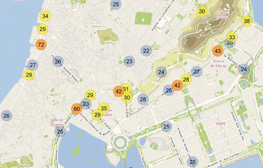
This handout image provided by the Public Security Police (PSP) on Wednesday shows differently coloured traffic accident blackspots on their new online map.