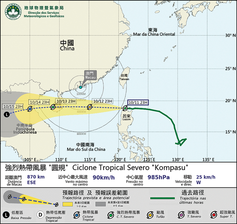
‘Relatively high possibility’ of Signal No. 8: SMG
The Meteorological and Geophysical Bureau (SMG) forecast on its website yesterday that Severe Tropical Storm “Kompasu” will come closest to Macau between today and tomorrow morning.
Standby Signal No. 1 was hoisted by the bureau at 8 p.m. yesterday, which might be replaced by Signal No. 3 “at dawn.”
Signal No. 1 means that a tropical cyclone is centred within 800 km of Macau and may affect the city.
Signal No. 3 means that Macau is being impacted by a tropical cyclone, and winds with a sustained speed of 41 to 62 km/h are expected or blowing and the gusts may exceed 110 km/h in the city.
Signal No. 8 means that a tropical cyclone continues to approach Macau. Winds with a sustained speed of 63 to 117 km/h are expected or blowing and the gusts may exceed 180 km/h in the city.
The observatory also said that there was “a relatively high possibility” that Signal No. 8 could be hoisted between tonight and early tomorrow morning.
At 11 p.m. “Kompasu” was located about 870 km east-southeast of Macau and moving toward Hainan province.
The weather station pointed that the tropical storm was expected to continue to strengthen between today and tomorrow, adding that it was forecast to move across the northern part of the South China Sea, and would be closest to Macau, around 400 km south of the city, before heading towards Hainan.
The bureau said that the wind in Macau was expected to intensify today due to the storm’s proximity to the city, coinciding with a northeast monsoon. It also pointed out that unsettled weather was expected to occur between tonight and tomorrow, predicting heavy rain and thunderstorms while “the maximum wind may reach Wind Force Level 8, with gusts”.
Level 8 according to the Beaufort scale indicates gales reaching a wind speed of between 62 and 74 km/h
Tomorrow at midnight, flooding at a level below 0.50 metres is expected to occur in the city’s low-lying areas due to the combined effect of storm surge and high astronomical tide, according to the bureau.
Meanwhile, in a separate statement, the Unitary Police Service (SPU) urged the public to take precautions against the typhoon and flooding.
The statement recommended that the public check whether their doors and windows are secured, to fasten objects that could be blown away during the storm and to pay attention to updates by the government about the tropical cyclone.
Kompasu will be the second typhoon to affect the region, after Typhoon “Lionrock” over the weekend.