According to the latest forecast by the China Meteorological Administration (CMA) yesterday, an area of low-pressure located in waters east of the Philippines keeps on developing and was on track to intensify into the fifth typhoon of this year, named Dusuri, as early as today, with its track possibly moving north to southern China next week,
According to a CMA statement, Dusuri is expected to be stronger than Typhoon Talim that spared Macau on Monday.
Dusuri has been named by South Korea, and means “vulture” in Korean.
The forecast said there was still uncertainty about whether Dusuri will move north or straight to southern China, with its direction currently moving to the South China Sea via Luzon in the Philippines.
However, the path forecast for next week could be very different, so it still needs to be continuously tracked and observed, the CMA statement pointed out.
The forecast said that no matter where the low-pressure area is going to move, Macau will experience hot weather caused by a high pressure area in the coming days.
Therefore, even if the low-pressure area does not move closer to Macau and cause a direct impact, thunderstorms might still be triggered by high temperatures, accompanied by strong gusts, which may cause a certain degree of damage, according to background information released by the Macau Meteorological and Geophysical Bureau (SMG).
Moreover, apart from Dusuri, the forecast also said another typhoon was expected to form in the next 10 days, and the CMA urged residents to be wary of the current weather.
Members of the public can get the latest weather information from the SMG website at https://www.smg.gov.mo/zh.
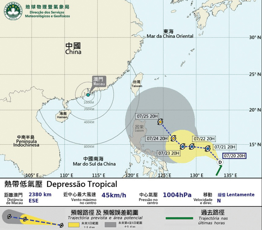
This infographic provided by the Meteorological and Geophysical Bureau (SMG) yesterday shows the expected track of Typhoon Dusuri which could threaten Macau next week.