

Macau's Meteorological and Geophysical Bureau (SMG) issued Strong Wind Signal No. 3 at 6 p.m. today, saying that it will remain hoisted today.
According to a statement by the bureau, this “means that under the influence of a tropical cyclone, winds with a sustained speed of 41 to 62 km/h are expected or blowing, and gusts may exceed 110 km/h in Macau”.
Based on the current forecast track, the bureau said, Typhoon “Noul” is moving generally northwest towards the eastern coast of Guangdong.
“Noul” is expected to make landfall along the coast approximately 170 kilometres east of Macau between midnight and tomorrow morning, the bureau said.
However, the bureau expects that after “Noul” makes landfall, Macau will experience southwesterly winds tomorrow morning, adding that “as there is no terrain barrier to influence the winds and it will be accompanied by frequent heavy showers, the wind force will further increase”.
Meanwhile, according to the statement, as the possibility of the landfall location of “Noul” being further westward and closer to the Pearl River Estuary cannot be ruled out, the probability of issuing the Typhoon Signal No. 8 tomorrow morning remains low to moderate.
The bureau forecast that there will be more thunderstorms and strong gusts in Macao tonight, with a high risk of severe convective weather*. Heavy showers and thunderstorms are expected tomorrow, the bureau said, and precautions should be taken against possible flooding due to heavy rainfall.
Meanwhile, the Hong Kong Observatory said this evening that it will issue Typhoon Signal No. 8 at 10.10 p.m. today as "Noul" barrels towards the region, with more than 380 flights cancelled and winds associated with the storm causing a scaffolding collapse.
The World Meteorological Organisation (WMO) defines a typhoon as a tropical cyclone reaching maximum sustained speeds ranging between 118-149 km/h (severe typhoon: 150-184 km/h; super typhoon: ≥185 km/h).
*Convective weather is severe atmospheric instability caused by warm, moist air rising rapidly, creating intense vertical clouds that produce hazardous weather conditions. - Google AI
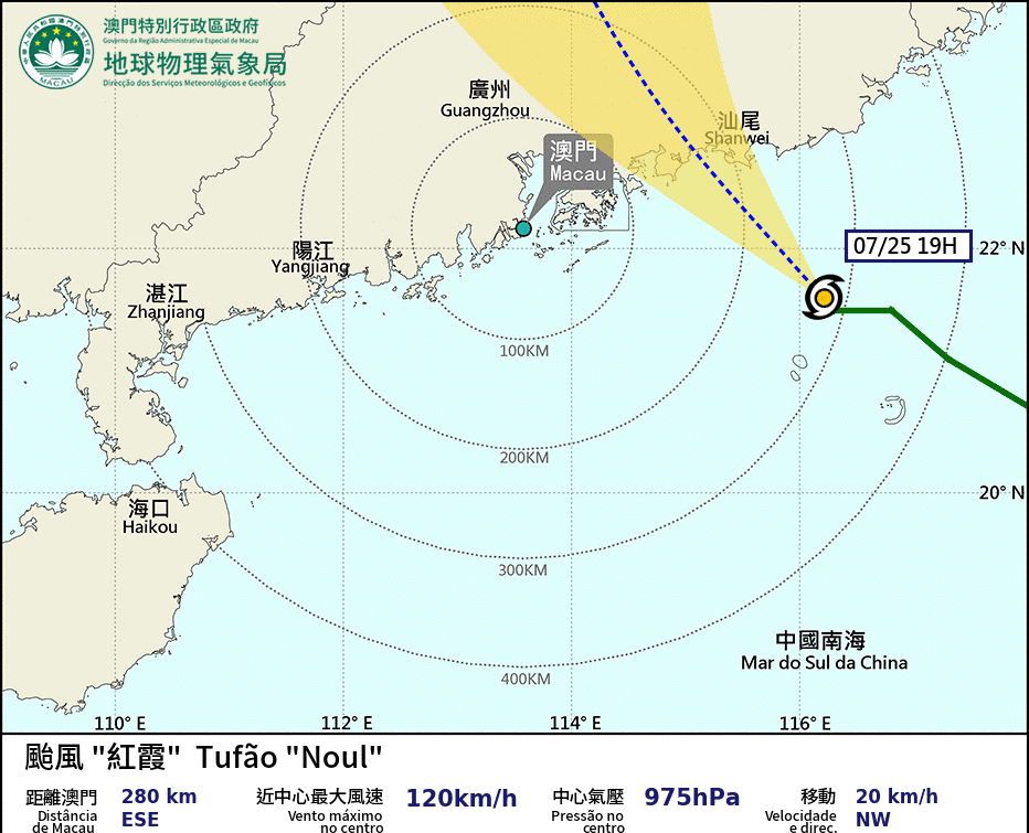
Typhoon map courtesy of SMG