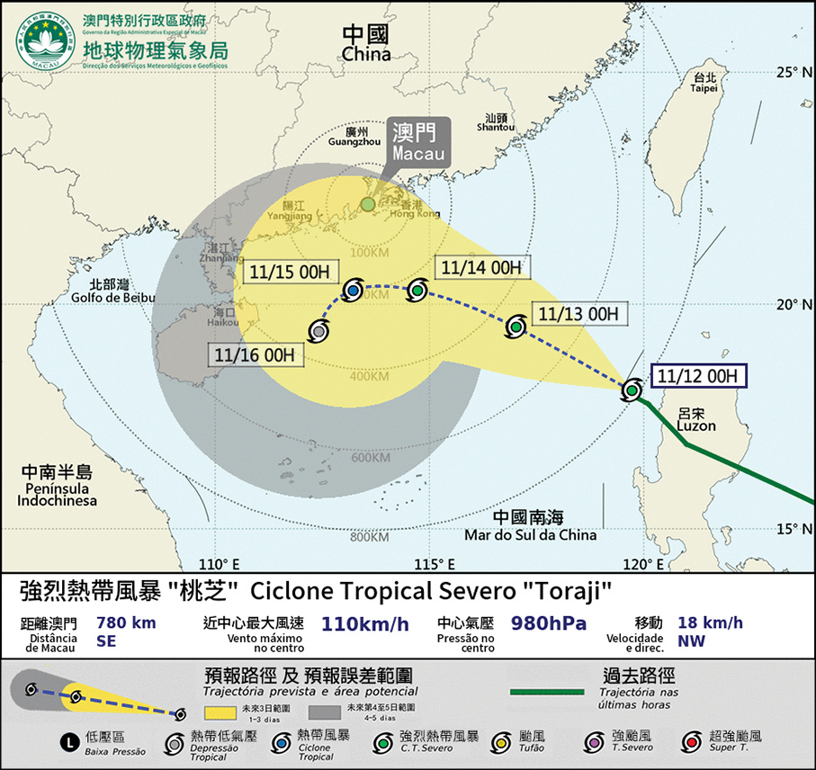
Tropical Storm Toraji (桃芝) will come within 800 kilometres of Macau early today, while there are currently three other tropical cyclones in the South China Sea and the Northwest Pacific Ocean, according to the observatory’s tropical cyclone warning signal system last night.
The Meteorological and Geophysical Bureau (SMG) hoisted the No.1 standby signal at 00:30 a.m. this morning and it will remain in force today.
Hong Kong’s observatory hoisted the No.1 standby signal at 10:20 p.m. last night, and will consider hosting the Strong Wind Signal No.3 later today to early tomorrow.
SMG forecast on its website yesterday that after Toraji enters the South China Sea, it will move in a north-westerly direction and approach the coast of southern China, and may pass 200 kilometres south of Macau in the middle of this week. Therefore, there is a medium to relatively high possibility that the No.3 signal will be raised.
However, as the sea temperature in the northern part of the South China Sea is relatively low and it is already late autumn, there is a lack of water vapour in the South China Sea for Toraji to transport, so there is still a great deal of uncertainty in the change of the intensity of Toraji.
The local observatory forecast that there will be more sunshine during the daytime in Macau in the next 2 days under the influence of the northeast monsoon, and as Toraji approaches, there will be more clouds and rain showers in the middle and latter part of the week, with the wind being strengthened.
Meanwhile, the observatory forecast that the other three tropical cyclones will continue to move in a westerly direction and cannot be ruled out from entering the South China Sea for the time being. The bureau will continue to track the movements of the tropical cyclones.

This infographic provided by the Meteorological and Geophysical Bureau (SMG) yesterday at 1:55 a.m. shows the expected track of Tropical Storm Toraji.


