The Meteorological and Geophysical Bureau (SMG) said in a statement last night that it expected to hoist tropical cyclone signal No. 3 between tonight and early tomorrow morning.
According to the statement, the tropical cyclone standby signal No.1 was issued at 8 p.m. yesterday. The statement also said that signal No.1 would remain in effect for a period of time.
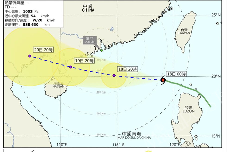
At midnight, the unnamed tropical depression was located about 630 km east-southeast of Macau and was moving towards the western coast of Guangdong province, the bureau said, adding that it was forecast to move west at around 25 kilometres per hour.
The statement pointed out that the tropical cyclone would bring unstable weather to Macau. The bureau said that the city could expect more frequent rainfall, rainstorms and strong winds between today and Thursday.
The statement warned that flooding will occur in the Inner Harbour area, adding that the bureau expected the flood water to be up to 0.5 metre in height.
The Labour Affairs Bureau (DSAL) urged construction sites in separate statement last night to be prepared for strong winds. The bureau advised people not to go near construction sites when storm signals are hoisted.

This image taken from the website of the Meteorological and Geophysical Bureau (SMG) late last night shows the projected trajectory of the tropical depression heading toward the western coast of Guangdong province.


