Macau’s Meteorological and Geophysical Bureau lowered all strong wind signals and storm surge warnings yesterday as Severe Tropical Storm “Ma-on” moved further away from the city.
The observatory lowered the Strong Wind Signal No.3 at 6:30 p.m., which it had hoisted at 11 a.m. yesterday when it replaced the Severe Tropical Storm Signal No.8 that had been hoisted at 10:30 p.m. on Wednesday.
The weather station cancelled its storm surge warning at 10 a.m. as minor floods in the city’s low-lying areas had subsided by then.
The observatory forecast today’s weather to be cloudy with sunny intervals and occasional showers.
Ma-on goes soft on Macau
Meanwhile, the Civil Protection Operations Centre (COPC) said in a statement yesterday that no major damage or even minor injuries were reported during Ma-on.
The statement noted that five incidents were recorded during the period when Signal No.8 was up, namely a case of a falling tree, a case of collapsed scaffolding, two cases of falling windows, and a case of damage to a breakwater.
The statement pointed out that in view of the combined influence of the high astronomical tide and the storm surge, the government had activated its storm surge evacuation plan for low-lying areas at 8 p.m. on Wednesday. During the operation, 8,730 households were verified on site, 2,514 people were evacuated and 438 people from 285 dwellings refused to evacuate from the low-lying areas.
In response to the Orange storm surge warning hoisted at 8 p.m. on Wednesday, the Social Welfares Bureau (IAS) had opened its 16 emergency shelters and four emergency assembly and pick-up points to the public, with 96 people having used them during the severe tropical storm, the statement said.
According to the analysis of the Meteorological and Geophysical Bureau (SMG), the floods were not as severe as expected as the peak of the impact caused by the storm surge did not coincide with the peak of the astronomical tide, the statement said, adding that therefore Ma-on did not affect the city’s tap water and electricity supplies.
This year’s 3rd Signal No.8
Meanwhile, according to separate SMG statement yesterday, under the impact of Ma-on, the bureau issued this year’s third Severe Tropical Storm Signal No.8 on Wednesday. During the hoisting, the maximum 20-minute average wind speed on the city’s three bridges was generally recorded as Force 8-9, with the maximum gusts reaching Force 10.
According to the Beaufort Wind Scale, Force 8 indicates Gale, Force 9 indicates Severe Gale, while Force 10 indicates Storm. The scale ranges from 0 (Calm) to 12 (Hurricane).
The statement said that although Ma-on intensified to typhoon level when it was approaching the coast of Guangdong province, due to the combined impacts of vertical wind shear in the northern South China Sea and the drier air on Ma-on’s northeast side, the development of its rainband had been restricted, and that heavy rains were concentrated in Ma-on’s south side, while Macau was located on its north side.
The statement noted that as of 11 a.m. yesterday, 10 millimetres of accumulated rainfall was generally recorded in the city during Signal No.8.
The observatory pointed out that although Ma-on eventually intensified to typhoon level and passed about 160 km west of Macau, the unexpected movement speed, general track and place where it made landfall had affected the severity of the storm surge, and that also made the time of the astronomical high tide and storm surge “obviously” out of phase so that yesterday morning’s flooding was not as severe as it had expected.
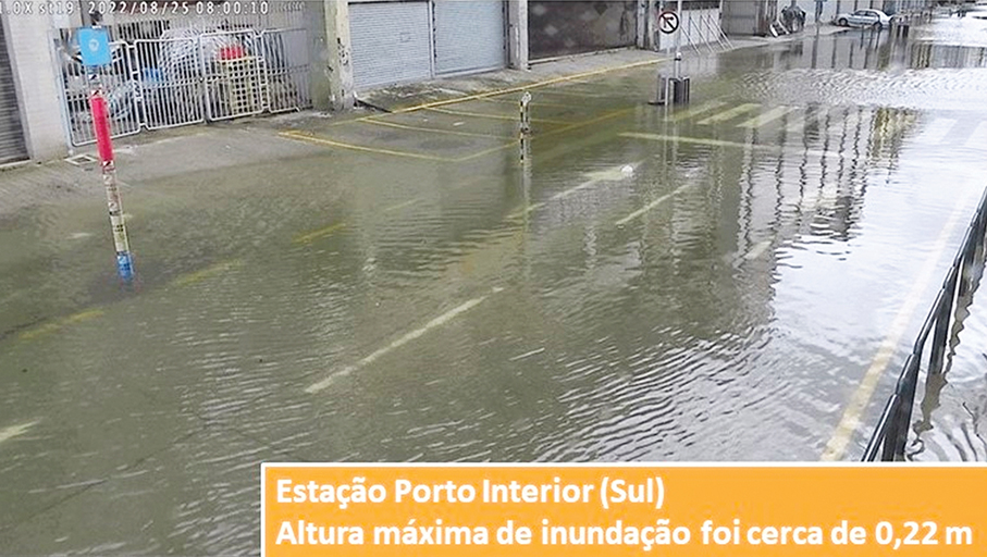
This handout photo provided by the Meteorological and Geophysical Bureau (SMG) shows floods reaching only 0.22 metres in the Inner Harbour area yesterday morning.