The Meteorological and Geophysical Bureau (SMG) said in a statement yesterday that according to the latest forecast, a low-pressure area located in the northwest of the Pacific Ocean has a high probability of becoming a tropical storm in the next few days, which, however, was still quite far from Macau, with its track still being undetermined.
The statement added that the atmospheric conditions where the low-pressure area was located were quite favourable for its development, so it was “very likely” to develop into a super typhoon.
The statement underlined that the bureau will closely monitor the low-pressure area’s evolution and disseminate the relevant information to the public in a timely manner, while urging the public to keep abreast of the most up-to-date weather information and meteorological warning signals.
Meanwhile, in the statement the bureau gave a conclusion of the impact Typhoon Talim had on Macau, pointing out that during the typhoon, according to the Beaufort scale, the maximum 10-minute average wind speed of 8-9 (gales and strong gales) was recorded on the three Macau-Taipa bridges, when the maximum gusts reached 10 on the scale ranging from zero (calm) to 12 (hurricane force).
Talim was the first tropical cyclone to affect Macau this year, while the No. 8 typhoon signal had been in effect for 14 ½ hours.
The observatory cancelled all tropical cyclone warning signals at 10:30 a.m. yesterday.
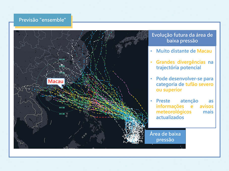
This infographic image provided by the Meteorological and Geophysical Bureau (SMG) yesterday shows the track of next week’s “highly probable” typhoon that could threaten Macau.