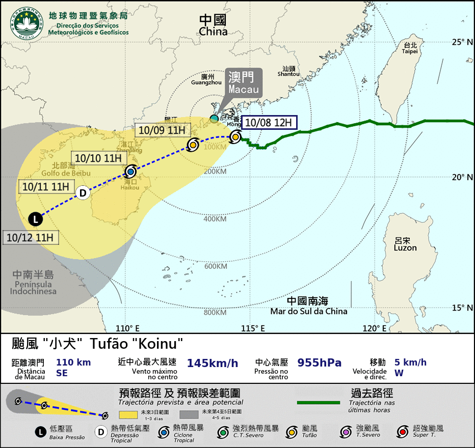
The Macau Meteorological and Geophysical Bureau (SMG) has said in a statement that it will hoist the Typhoon Signal No.8 at 4:30 p.m. today.
According to the SMG website, at 1 p.m. Typhoon Koinu was located some 110 kilometres southeast of Macau.
Typhoon Koinu is moving slowly and will come within 100 km of Macau between this afternoon and tonight, the observatory noted, forecasting that gales will affect Macau, the weather station said, which predicted occasionally heavy rain for today and tomorrow.
The observatory also said that as the track of the typhoon was more northward than expected, "There may be flooding below 0.5 metres caused by a storm surge in low-lying areas between midnight and tomorrow morning, adding that the Blue Storm Surge Warning will be issued at 2:00 p.m. today.
The hoisting of the Typhoon Signal No.8 indicates that "winds with a sustained speed of 63 to 117 km/h are expected or blowing while gusts may exceed 180 km/h in Macau," according to the SMG website.
When No.8 is up, Macau's public bus transport and ferry are suspended. No.8 is the third highest of Macau's five-level storm warning system (1, 3, 8, 9, 10).
Currently, the Strong Wind Signal No.3 is hoisted.
Blue is the lowest of Macau's five-level storm surge warning system (Blue, Yellow, Orange, Red, Black). Blue indicates that the water level is expected to be below 0.5 meter above road level.
Meanwhile, the Hong Kong Observatory issued the Gale and Storm Warning Signal No.8 at 12:40 p.m. today. Typhoon Koinu is expected to come within 100 kilometres of Hong Kong, it said, forecasting heavy squally showers for today and tomorrow.


