


The Meteorological and Geophysical Bureau (SMG) hoisted Stand-by Signal No.1 at 11:00 p.m. yesterday as a tropical depression developing over the south-central South China Sea was moving within 800 kilometres of Macau.
According to an SMG statement, there is a “medium” probability of hoisting Strong Wind Signal No.3 tomorrow morning.
According to the bureau, the tropical depression was forecast to gradually intensify over the next few days while tracking generally towards the nation’s southernmost island province of Hainan.
Under the system’s influence, winds in Macau are expected to strengthen gradually tomorrow, occasionally reaching Force 6 on the Beaufort scale*, accompanied by frequent showers, the statement said, adding that windy conditions will persist over the weekend, with periods of heavy rain expected at times.
The local observatory advised residents to stay alert to changing weather conditions and monitor its latest forecasts and tropical cyclone warnings as the system develops, adding that it will continue monitoring the tropical depression closely and urged the public to keep up to date with its latest weather information and warning signals.
*The Beaufort Scale is a 12-point empirical system that measures wind intensity based on observable physical conditions at sea or on land, ranging from Force 0 (Calm) to Force 12 (Hurricane). Devised by British Admiral Sir Francis Beaufort in 1805, it remains a valuable tool for sailors, meteorologists, and coastal residents to estimate wind speed without instruments. - Gemini
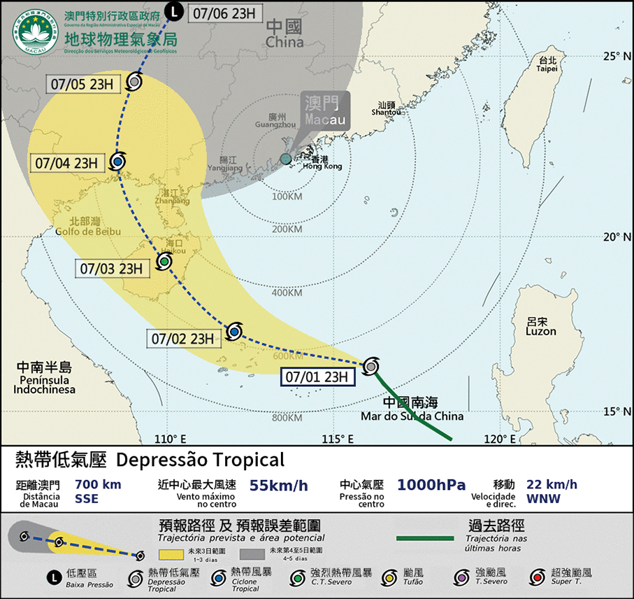
This infographic provided by the Meteorological and Geophysical Bureau (SMG) yesterday at 11:00 p.m. shows the expected track of the still unnamed tropical depression moving towards Hainan Province from the South China Sea.