The government’s planned flyover connecting the Zone A land reclamation area and Nape will be 1,650 metres long, the Public Works Bureau (DSOP) announced on its website yesterday.
According to the website, the vehicular overpass known as AB Link, will run from near the Kun Iam Statue on the Nape waterfront to the roundabout outside the Macau Science Centre (MSC), from where it will cross the sea running under the Macau-Taipa Friendship Bridge and finally arrive in Zone A.
In addition, the website says, the AB Link will also be connected with the fourth Macau-Taipa Bridge that will connect the Zone A and Zone E1 land reclamation areas.
The ongoing fourth Macau-Taipa Bridge project is now scheduled to be completed in March next year.
The government plans to have a total of four vehicular links between Zone A and the peninsula, namely A1, A2, A3, and AB.
The A1 Link refers to the current vehicular connection between Zone A and the busy Oriental Pearl roundabout (Rotunda da Amizade) on the peninsula’s north-eastern coast, while the A2 Link refers to a two-way flyover that will connect Zone A and an area near the Macau Peninsula Wastewater Treatment Plant. The A2 flyover project, which got off the ground in November last year, is scheduled to be completed in October next year.
The planned A3 Link refers to a flyover that will connect Zone A and an area near the Outer Harbour Ferry Terminal. The government is still designing the A3 Link.
The bureau announced on its website yesterday that the government has hired CCCC Highway Consultants Co., Ltd. Macau Branch to carry out the preliminary design of the AB Link project for a price tag of 23.88 million patacas. The company is required to complete the preliminary design in 135 days.
For the time being the government does not have a timetable as to when the A3 Link and AB Link projects would get off the ground.
Zone A is primarily being developed for public housing projects.
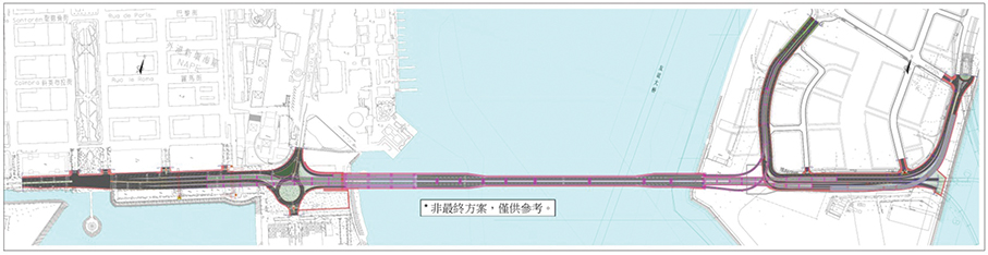
This map downloaded from the Public Works Bureau’s (DSOP) website yesterday shows the plan for the government’s flyover project connecting Zone A and Nape.