The government has published a revised version of its urban development plan for the largely undeveloped area in Taipa where Cheok Ka Village and Sam Ka Village are located, according to which the neighbourhood near central Taipa is now earmarked to have a smaller population and to be covered by larger green areas, compared to the previous version published in 2013.
The plan’s new version aims to advance urban development of the area, where numerous privately-owned plots of land are scattered and irregularly shaped, while also ensuring stronger protection of officially-listed old trees in the area.
The plan’s new version aims to create a residential and commercial area, integrated into the surrounding hillside landscape, bringing together diverse lifestyles and business activities.
The newly revised plan was uploaded onto the DSSCU website yesterday.
The urban development plan for the area is officially known as Taipa Northern Zone Urban Development Plan.
Lands and Urban Construction Bureau (DSSCU) officials briefed members of the Urban Planning Council (CPU) about the new version of the Taipa Northern Zone Urban Development Plan during a regular meeting of the government-appointed council yesterday.
The meeting, chaired by DSSCU Director Lai Weng Leong, was open to the media. The council is a consultative body tasked with advising the government on its urban planning policies.
The area of two adjacent villages, Cheok Ka Village (卓家村) and Sam Ka Village (三家村), which is still largely undeveloped, is situated between the former campus of the University of Macau (UM) and the Lago (Lake) subsidised home-ownership scheme (HOS) housing estate (湖畔大廈).
In the newly revised plan’s introduction, the government states that in compliance with new urban planning requirements listed in Macau’s official urban master plan, which took effect in February 2022, it decided to revise its Taipa Northern Zone Urban Development Plan, with the aim of promoting the development and use of land in the area, advancing the neighbourhood’s urban development, and improving the living environment of those living in and near the area.
The total area covered by the urban development plan’s new version amounts to 222,000 square metres, around the same as the previous version.
The plan’s new version notes that Macau’s official urban master plan earmarks the area as a residential neighbourhood.
The plan’s revised version earmarks 54 plots for urban development in the area, 28 of which are earmarked for residential projects.
Other plots in the area, according to the revised version, are earmarked for commercial and office spaces, government buildings, and infrastructure, as well as tourism, cultural, education, social service, recreational, health, and municipal facilities.
According to the plan’s new version, the gross construction areas of the various buildings and facilities will amount to 1.05 million square metres, a decrease from the 1.26 million listed in the previous version.
The new version of the plan earmarks a population of 20,000 in the area, 45.2 percent down from the 36,500 residents there envisaged in the 2013 version.
According to the plan’s revised version, the government plans to extend the current elevated walkway along Avenida de Guimarães (基馬拉斯大馬路) in central Taipa, through the area, to the Macau Anglican College located near the former UM campus.
According to the new version, the government plans to set up two parks in the area, one of which will be built where the current cluster of 10 officially protected old trees is situated.
The Macau Special Administrative Region’s (MSAR) urban master plan for 2020 to 2040 divides the city into 18 “subareas for planning”.
After the urban master plan took effect in February 2022, the government drew up its first urban development plan for a subarea for planning, i.e., Eastern District 2, which covers the Zone A land reclamation area. The government’s Eastern District 2 urban development plan took effect in March 2024.
The Eastern District 2 urban development plan is the first and so-far the only one currently in force for a subarea for planning listed by the urban master plan. The government is still working on drafting urban development plans for several other subareas required by its urban master plan.
According to the urban master plan, the Cheok Ka Village and Sam Ka Village area is covered by the Taipa Central District 2 urban development plan, which the government is currently still drafting, and on which a public consultation is yet to be launched.
In addition to the undeveloped Cheok Ka Village and Sam Ka Village area, Taipa Central District 2 also covers central Taipa, the island’s “city centre” where numerous high-rise residential buildings are concentrated.
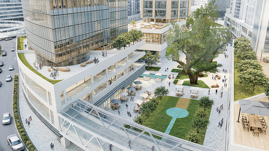
This artist’s rendition in the revised version of the government’s Taipa Northern Zone Urban Development Plan released yesterday shows the future park surrounded by future buildings where the current cluster of 10 officially protected old trees is situated.

This artist’s rendition in the plan’s new version shows the future extension of the current Avenida de Guimarães skywalk into the currently undeveloped area, integrating with podium areas of future buildings there.